Here's the background application behind this weekend's (April 1-2, 2023) protests around St. Mary's Street which is SW of Bloor and Yonge in downtown Toronto. It's a twenty page PDF file.
https://www.toronto.ca/legdocs/mmis/2021/te/bgrd/backgroundfile-171277.pdf
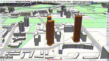
Did you know that you can infer movement and animation out of some of this data - the city and developers supply CAD files in a format that can be read on-line by Trimble's SketchUp program.
Note that I'm a newcomer to the game... I may
sound like I know what I'm talking about but it took me five weeks to even begin to get a handle on the the document set for the application (by Osmington Gerofsky Development Corp.) to build a 50 storey skyscraper condominium on the lot where I live - which is literally across the street from the Science Centre.
I spoke with the one of the chief planners a week ago, at a meeting organized by the local councillor. He (the planner) agreed that the
A.I.C. (a set of web pages related to the documentation set around development proposals) needed work.
Modelling or not, the closest condominium buildings operate as a sort of semi-gated community. The notion of opening up an entire city block to "bike" and pedestrian paths (how do those two mix exactly?) a few hundred yards from the
C.P.R. seems ill advised.


 ...attached, pic goes back several years and yes, that is an I.S.A.C. (the Income Security Advocacy Centre) staff member calling the honourable member a liar! She was promptly escorted out. (The staffer not the Minister.)
